
📍 Send me your field’s location, and I’ll manually prepare your NDVI map, zone boundaries, and a English or German or French or Spanish or Romanian language report for you.

❌ Don’t know where crop condition is weaker?
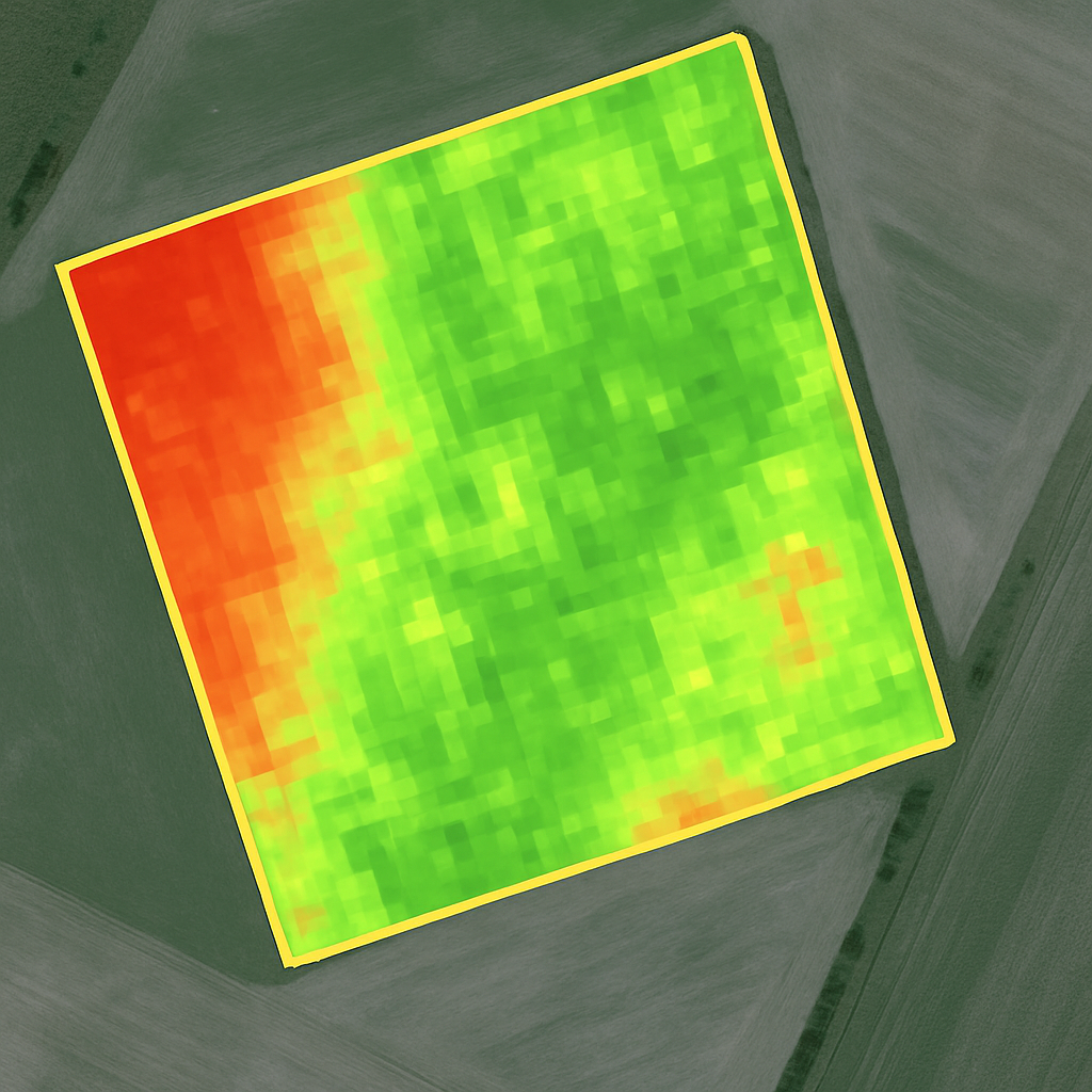
The eye can’t see what the satellite can. The color NDVI map will show it.

❌ Applying inputs unnecessarily?
With zones, you can target nutrients and crop protection more precisely.

❌ No drone or software?
No need for them. I work from satellite images – fast and accurate.

❌ Agricultural analysis systems too complicated?
The report is clear, in 5 choosen languages, and straightforward – no need to be an expert.
current crop condition in color, from satellite (Sentinel)
automatic division of the field into 2–5 areas of different condition
simple 5 choosen languages written evaluation + application recommendations
just a parcel number or GPS points are enough
Today’s farmers have valuable time – that’s why we keep everything simple and handle all communication by email, with no unnecessary steps. You can send questions, orders, or requests from home or even from the tractor cab. No queues, no waiting – we offer fast and convenient online solutions. Every inquiry receives a precise, professionally grounded answer, so you can be sure we understand your needs. We believe that 21st-century farming works best with digital support and a modern approach – and we provide effective assistance for this every day.
The report is custom-made
Uses the latest Sentinel-2 satellite images
On request, SHP, GeoTIFF, or KML export is available
EU-developed, with EU support
Simple, email-based process – no registration
Future upgradable subscription system with AI support

The first 10 hectares are free. After that, the price is 1€/ha + VAT.”
I will send it by e-mail within 1–3 working days.
-Yes, upon request, SHP, KML, or GeoTIFF export is also available (for an additional fee).
Your name, email address, and the location of the field (GPS, parcel number, or map link).

„Nem gondoltam volna, hogy ennyi minden kiderül egy egyszerű NDVI térképből. Nagyon hasznos volt!”

„Gyors, pontos és világos riport. Nem kellett semmit telepíteni, minden érthető volt.”